

GPS has become the principal means of navigation for pilots operating in US airspace and in many other parts of the world. That means GPS signal degradation or interference events can have a significant impact on
flight operations. As a result, the Federal Aviation Administration (FAA) asked MITRE, the operator of its federally funded R&D center, to develop and prototype a broad range of capabilities to monitor GPS signal degradation events and assess their impact on aircraft navigation. The result is the prototype Navigation Operational and Planning Agility Suite (NOPAS).
NOPAS is the first generally available application for the US Government that combines the capability to detect and depict GPS loss-of-service events, along with the availability of alternative ground-based navigation services, in a single web-based capability.
Improving preparedness
Two challenges spurred the development of NOPAS. One is that GPS signal interference events are increasing. And, while most of these events are accidental – often the result of GPS repeaters being left on after aircraft system testing – there is also the potential for malicious interference with GPS signals.
Regardless of their cause, GPS interference events can be disruptive. They may result in flight cancellations or diversions, as was the case in the 2022 interference events in the Denver, Colorado and Dallas Fort Worth (DFW), Texas areas in the USA. At best, they require pilots to revert to using older systems for navigation, whether Distance Measuring Equipment (DME), Very High Frequency Omnidirectional Range (VOR), or radar vectoring. So, when GPS interference occurs, the FAA, airlines, pilots, controllers, dispatchers, and other aviation stakeholders need to know as quickly as possible. Fortunately, as the result of a 2020 federal mandate requiring Automatic Dependent Surveillance-Broadcast (ADS-B) equipment aboard aircraft, key data to make these determinations became available.
Another key driver for NOPAS is the fact that the US Department of Defense (DoD) has significantly ramped up testing and training operations where GPS signals are purposely degraded.
GPS signal interference is common in conflict areas, such as Ukraine and parts of the Middle East, so the DoD conducts exercises in the US National Airspace System (NAS) to prepare warfighters for these scenarios. These exercises can impact the GPS navigation of aircraft flying through the impacted test area. As a result, the FAA is seeking an enhanced capability to assess the impacts these events can have on air traffic. This will enable the FAA to better coordinate with the DoD on the times and locations where these planned GPS interference exercises occur.
NOPAS is designed to address all of these planned and unplanned GPS degradation scenarios.
Unplanned GPS degradation events
Currently in the USA, when a GPS degradation event occurs air traffic controllers typically find out through pilot reports. The FAA can then initiate an investigation. But that takes time. NOPAS speeds up the process dramatically, using data from aircraft transmissions to identify GPS degradation events in near-real time.
It does so by analyzing the GPS navigational integrity data from an aircraft’s ADS-B data messages, which include not only aircraft position data but also several navigation quality metrics. If NOPAS algorithms detect that a substantial number of ADS-B messages in a given airspace have degraded navigational integrity, it flags that area as being impacted in that time period.
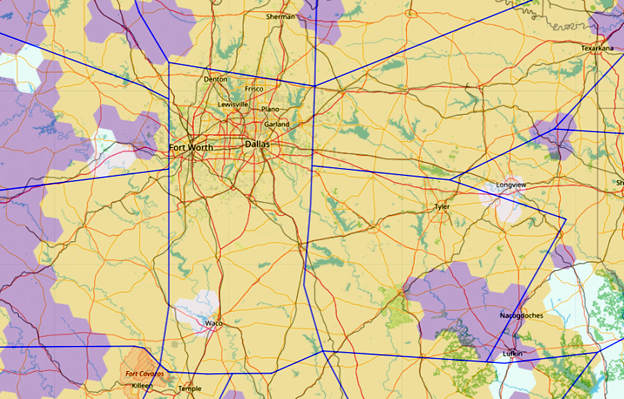
The NOPAS system then maps these areas on an easy-to-understand display, using color-coding to indicate the severity of the GPS degradation event (see Figures 1, 2, 3). A coloured map overlay shows the other navigation systems pilots can use in the affected regions. These areas are depicted as hexagonal shapes, using the open-source H3 geospatial standard originally developed by Uber.
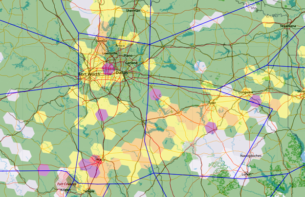
Figure 1 is a NOPAS depiction of the status of GPS signal degradation. Figure 2 depicts the availability of ground-based navigation based on DME and VOR for the same area. Figure 3 depicts the status of GPS signal degradation for aircraft and includes the availability of ground-based navigation when the status of GPS navigation is characterized as unacceptable based on the parameters set by the user.
The unacceptable NOPAS classification describes an area in which multiple aircraft are experiencing a degradation of normal GPS performance; it does not mean that aircraft flying through these areas are unsafe or noncompliant with aviation navigation requirements. Figure 3 combines the key information from Figures 1 and 2.
Those maps are designed to give personnel at the FAA air traffic control system command centers (ATCSCC) and air traffic control facilities the information they need – at a glance – to know what they’re dealing with and their options for handling the situation.
For instance, if DME provides sufficient coverage in the area, most air carrier aircraft can use the ground-based signals DME generate to navigate almost as effectively as with GPS. Aircraft not equipped with DME avionics may need to rely on VOR navigation. Other situations may call for slowing traffic down so that it can be managed through radar vectoring, an option that adds significantly to controller workload and therefore limits airport capacity. In a worst-case scenario, aircraft may have to be diverted to other destinations unaffected by the GPS degradation event.
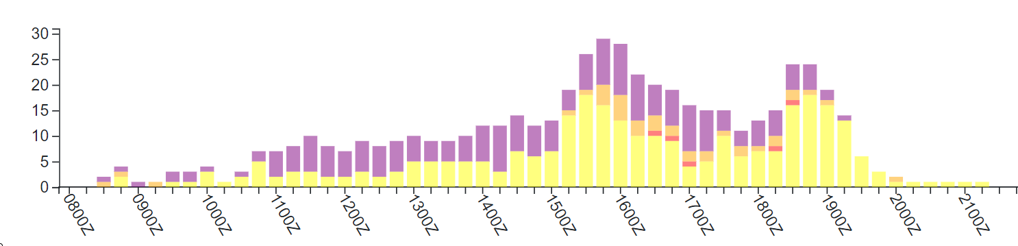
NOPAS can also identify the impact of the GPS degradation event over time. A user can draw a circle on the heat map and NOPAS displays the number of impacted hexagons on a bar chart, as illustrated in Figure 4. For the Dallas Fort Worth event on October 18, 2022, the peak impact was between 1500Z and 1600Z.
With the added information NOPAS provides, the FAA will be able to make decisions about how to manage traffic during a degradation event more quickly and effectively. While the impacts of a GPS interference event can last for several days, NOPAS – used as part of a coordinated response by the FAA and other parts of the US Government – has the potential to mitigate those impacts within a few hours.
A more rapid response can also reduce the need for more disruptive options, such as holding patterns and diversions to alternate airports. All of these options adversely affect airlines, their passengers, and the environment through increased delay, fuel use and carbon emissions.
Scheduling GPS interference
NOPAS will also help the FAA better coordinate with the DoD on the scheduling of planned GPS interference events for military exercises.
The two agencies already coordinate, but they currently rely heavily on institutional knowledge to determine the best times for these tests. For instance, many are scheduled at night or at other times of day when traffic volumes tend to be lower. However, the FAA asked MITRE to develop a more objective way of measuring the potential impact of a planned test.
To achieve that, MITRE’s systems engineers are mining historical data to create traffic forecasts that can be used to estimate the impact of a testing event at any given location. NOPAS takes into account the airspace configuration, day of week and time of day, the length of the testing event, data about previous GPS degradation events, and other factors – all in one system. Sometimes, NOPAS may suggest that simply changing a test date by a single day or a test start time by an hour or two could reduce the impact on routine NAS traffic.
This capability will not only help the FAA prevent disruptions to commercial aviation traffic, but it will also help the DoD avoid test cancellations or interruptions, which the FAA has the authority to call for if a test proves to be too disruptive to air traffic. NOPAS can help prevent these sudden test interruptions, which currently occur several times a year at significant cost to the DoD.
Detecting spoofed GPS signals
The FAA has granted its personnel access to an Amazon cloud version of NOPAS for both added situational awareness and to obtain feedback on its functionality and usefulness. Those inputs will be used to further refine the prototype.
Work to expand and improve NOPAS’s capabilities is also underway.
A major goal for the next year is to accelerate data processing in NOPAS. The current version of the NOPAS prototype can identify a GPS degradation event within a few hours of when it began. Researchers are working toward a goal of detecting these events within 15 minutes, since the faster they can be identified, the better it is for everyone – the FAA, airlines, private pilots, and the flying public.
Another key focus for the coming year is to develop the capability to identify GPS spoofing events, which pose an even greater danger to aviation safety than degradation events by providing misleading information that appears real. A possible consequence of this could be that an aircraft is drawn off course, for example. And pilots flying at low altitudes, especially in mountainous regions, would be at risk if relying on an incorrect signal for navigation.
MITRE-developed algorithms designed to detect spoofing using ADS-B data are currently being validated. While spoofing events in the USA are currently quite rare, the FAA plans to be ready if they become more common.
MITRE partners with government and industry
MITRE’s mission-driven teams are dedicated to solving problems for a safer world. Through public-private partnerships and federally-funded R&D centers, the company works across government and in partnership with industry to tackle challenges to the safety, stability, and well-being of the USA.
MITRE operates the Center for Advanced Aviation System Development, which has supported the FAA for more than 60 years. In addition, it provides technical expertise to various international civil aviation authorities, airport operators, airlines, and other aviation organizations in air traffic management systems engineering, aviation operations, airspace design, and systems automation and integration.